Preservation of the Third Day's Battlefield

By James J. Campi, Jr.; Hallowed Ground Magazine, 150th Anniversary Gettysburg
There was little rejoicing at Gettysburg on July 4, 1863. Despite the repulse of Pickett’s Charge on the previous day, the two armies continued to scowl at one another from their respective lines, licking wounds inflicted over the course of the three-day battle. Driving rain in the afternoon brought a modicum of relief for the weary soldiers, but could not wash away the scars of war that have forever after marked this landscape.

In the immediate aftermath of the battle, the focus of those who remained in Gettysburg was on tending to the wounded and burying the dead. Both involved enormous logistic issues for a small crossroads town with a population of just 2,400. On July 22, 1863, the network of division and corps hospitals scattered across the battlefield in private homes and barns (sites today marked with placards) was combined into one facility: Camp Letterman. To this hospital camp, which revolutionized the science of field medicine, just a week after the battle, arrived military artist and cartographer Col. John B. Bachelder.
Bachelder visited with the recuperating officers, recording their memories of the battle while they were still fresh. He also spent days ranging across the battlefield, sketching and mapping. As the soldiers recovered, many joined him on these expeditions, helping firmly connect locations on the battlefield with specific events. Not only did these interviews provide the basis for the body of scholarship that ultimately made Bachelder the most widely regarded expert on the battle, but they also laid the groundwork for preservation priorities at Gettysburg.
Meanwhile, plans were also soon underway to tend to the Union dead. As with most Civil War battles, the dead had been hastily buried by their comrades near where they had fallen. These graves were inevitably shallow affairs, given the exhaustion of the soldiers who remained in the aftermath of battle. There was a genuine need — both as a gesture of respect for the honored dead as well as for public health — to give these men a proper burial.
Establishment of a cemetery for the Union dead was first proposed by local civic leader and attorney David McConaughy. In August, he circulated a letter to prominent local citizens, advocating for the creation of a soldiers’ cemetery, noting: “There could be no more fitting and expressive memorial to the heroic valor and signal triumphs of [o]ur army….”
Initially, McConaughy’s preference was to incorporate the soldiers’ burial ground into Evergreen Cemetery, the local burial ground that lent its name to now-famous terrain features Cemetery Hill and Cemetery Ridge. However, his vision conflicted with that of fellow Gettysburg resident and attorney David Wills, who sought the creation of a separate soldiers’ national cemetery adjacent to Evergreen. Unfortunately for McConaughy, the latter dream quickly prevailed. Wills was, after all, politically well connected, having been deputized by Pennsylvania governor Andrew Curtin to help organize medical care for the wounded. Later, President Abraham Lincoln stayed at the Wills’ home the evening before delivering his immortal Gettysburg Address during the formal dedication of the Soldiers’ National Cemetery. Today, the Wills House, restored to its 1863 appearance, is preserved and open to the public.
In many ways, the Gettysburg Soldiers’ National Cemetery was the model for Civil War-era national cemeteries throughout the country. The various states cooperated in creation of the cemetery and, as a result, the soldiers were interred into distinct state sections. In keeping with the 19th-century practice of cemeteries as park-like public spaces, famed botanist William Saunders (who also planned the park system in Washington, D.C.) was commissioned to incorporate memorial garden elements into his design.
McConaughy was more successful with the creation of the Gettysburg Battlefield Memorial Association (GBMA), the private entity that, for three decades, spearheaded efforts to preserve battlefield land at Gettysburg. In its first year, the association was able to preserve two tracts totaling 10 acres on East Cemetery Hill. McConaughy personally bought several other parcels that ultimately became part of the GBMA’s holdings. By the time it transferred its holdings to the federal government in 1895, the GBMA had preserved nearly 600 acres of the battlefield.
Although interest in preservation of the battlefield dates back to the week immediately following the battle, most of these efforts focused on protecting remaining earthworks and impressive visual features such as Cemetery Hill and Devil’s Den. These tended to be the locations of most interest to those early visitors to the battlefield in the decade immediately following the battle. It was assumed that the sweeping landscapes associated with the legendary charge by the divisions of generals Pickett, Pettigrew and Trimble would always remain farmland.
Like Cemetery Hill and Devil’s Den, Culp’s Hill was a popular tourist haunt during the decades that followed the battle. Its proximity to the town was one of the reasons for its fame. Further, the hill’s obvious battle scars also made it a destination for the curious. Because it was wooded, the impact of the fighting on Culp’s Hill in the form of shattered and scarred trees was obvious long after the fighting had ended. In addition, the earthworks constructed by elements of the Union XII Corps were frequently visited by early sightseers.

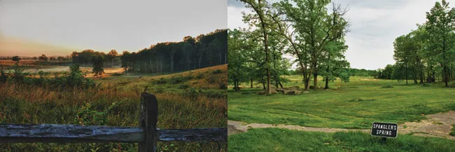
Fortunately, because of its rugged nature, Culp’s Hill has been spared some of the development pressures experienced elsewhere on the Gettysburg Battlefield. Improvements were made, however, to enhance the visitor experience. Trees were planted to replace those destroyed during the battle or cut down in the years following. Nearby Stevens Knoll was an early acquisition of GBMA. Slocum, Geary and Williams’ avenues were constructed to increase access to regimental monuments and the Union line, as was a steel tower to provide a commanding view of the northern end of the battlefield. The story of Spangler’s Spring, a natural spring at the base of Culp’s Hill used by both sides during the fighting, was memorialized with a monument in the late 1890s, including a dipper that allowed all visitors to enjoy a taste of the water.
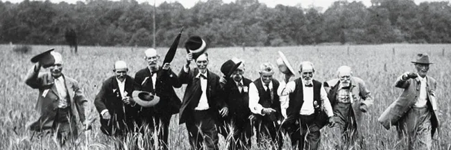
Wider interest in the formal preservation of Pickett’s Charge can be traced back to the veterans’ reunions held at Gettysburg. Immediately following the war, these reunions were sparsely attended — veterans were not always eager to revisit the scenes of such carnage. However, these initial reunions generated interest in placement of monuments to recognize the soldiers and units that fought at Gettysburg. It was also around this time that attention was drawn to the now-famous “copse of trees” as an important landmark of the July 3 assault.
Bachelder, who had become one of the leading directors of the GBMA, ultimately brought national attention to the area where Pickett’s Charge was focused. As part of his research to identify the locations of all the regiments that fought at Gettysburg, Bachelder corresponded with hundreds of soldiers. In the course of his study, Bachelder came to see the copse as being of singular importance to the battle and popularized the term “High Water Mark” to describe the location where Pickett’s assault on the Union line was broken. Artists of the era were also influenced by Bachelder’s work, including Frenchman Paul Philippoteaux, whose 1883 cyclorama was painted using the perspective of a person viewing Pickett’s Charge from Cemetery Ridge.
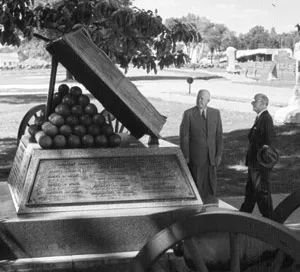
As noted, the veterans’ reunions led to discussion about placement of monuments on the battlefield. Union regiments that held the Angle were naturally eager to have their exploits memorialized in stone, and monuments, such as that of the 69th Pennsylvania Infantry, began to appear on the crest of Cemetery Ridge. In 1892, Bachelder’s dream of a monument recognizing the High Water Mark of the Confederacy was realized with the GBMA’s placement of the bronze open-book monument to the east of the Copse of Trees. The prominent equestrian statue of Maj. Gen. George G. Meade was formally dedicated four years later, in June 1896.
Of course, as with anything related to preservation at Gettysburg, the placement of the monuments was not without controversy. In 1887, at the direction of Bachelder, the GBMA first implemented the “line of battle” rule, which stated that battle monuments should be placed where units entered the fight. The new rule gave the GBMA wide discretion about placement of monuments on Association property. Further, since Confederate units often entered the battle a half mile or more from where significant fighting occurred, the new rule prevented Southerners from placing memorials near the more popular parts of the battlefield.
Veterans frequently disagreed amongst themselves and with the GBMA about where their monuments should be located. For example, the 72nd Pennsylvania Infantry wanted to place its monument in a prominent location near the Angle on Cemetery Ridge. Despite support for the regiment’s position from prominent Pennsylvania leaders, GBMA disagreed and rejected the proposal. A bitter legal battle ensued, eventually reaching the Pennsylvania Supreme Court, which ruled against the GBMA and allowed the regiment to move forward with its preferred location for the monument, where it rests today.

The first and most prominent of the Confederate state memorials was the State of Virginia Monument, completed in 1917, with its equestrian statue of Robert E. Lee gazing toward the copse of trees. Nearby sits the State of North Carolina Monument, dedicated in 1929, featuring members of Brig. Gen. J. Johnston Pettigrew’s division charging toward the Federal lines on Cemetery Ridge. The debate over which state — Virginia or North Carolina — advanced further on July 3, is memorialized in stone: a 26th North Carolina Infantry monument rests just a few feet in advance of the monument to Virginian Maj. Gen. Lewis Armistead, who fell mortally wounded inside the Angle.

As the veterans passed into history, new generations would become engaged in preservation at Gettysburg. In the early 20th century, the U.S. military began to engage in “staff rides” of Civil War battlefields to train future leaders in the dynamics of battle through examination of preserved battlefield terrain. With its proximity to West Point and the Army War College in Carlisle, Pa., Gettysburg was a popular choice for staff rides. A future advocate of preservation, Dwight D. Eisenhower, would first come to appreciate Gettysburg while in command of Camp Colt, a 200-acre World War I tank training base located on the site of Pickett’s Charge.
During the Depression, the Gettysburg Battlefield benefitted from a New Deal Civilian Conservation Corps (CCC) program. The park hosted two CCC camps — one in the Pitzer Woods named Camp Renaissance and another in the McMillan Woods that ultimately became one of the few all-African American camps in the CCC system. These young men performed considerable improvements to the park, installing trails, fences, roads and utilities lines. The CCC also reconstructed the XII Corps earthworks on Culp’s Hill and provided manpower for the 75th anniversary commemoration of the battle in 1938. During World War II, the CCC camps would be repurposed for reconnaissance training and psychological warfare, and as prisoner of war facilities.
As the fields associated with Pickett’s Charge rose in prominence, so too did efforts to protect both the Union and Confederate lines, as well and the landscape between. However, the area’s allure as a visitor destination also constituted the greatest threat to its integrity. Businesses, eager to capitalize on the tourist flocking to Cemetery Ridge, located stores, restaurants and hotels on the field of battle. Even today, Steinwehr Avenue in Gettysburg (which becomes the Emmitsburg Road, crossed by both Picket and Pettigrew’s men) is as renowned for its buffets and fast food eateries as it is for battle history.
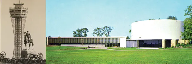
Private ventures weren’t alone in compromising the integrity of the July 3 battleground. As part of a 10-year plan to expand visitor facilities at national parks, in 1958 the National Park Service began work on a new visitor facility that would also include a rotunda for display of the Gettysburg Cyclorama. “Mission 66,” as the plan was called, emphasized improving interpretation and putting modern visitor facilities in central locations within national parks, often at the expense of historic landscapes. Most unfortunately, the site for the new visitor center was to be Ziegler’s Grove, a prominent feature on Cemetery Ridge. Further, the modern brutalist design of the building, which some equated to an alien spacecraft, ensured its incongruity within the battlefield landscape.
Subsequently, however, the National Park Service and other preservation advocates began to focus on restoring the battlefield to its wartime appearance. Thanks to its cooperation with production of the 1993 movie Gettysburg, NPS was able to begin burying power lines along the Emmittsburg Road. In its 1999 General Management Plan, NPS called for cutting nonhistoric woods, replanting historic orchards and rebuilding historic fence lines, as well as for the demolition of nonhistoric buildings on historic landscapes.
In 2000, the battlefield witnessed the end of the infamous Gettysburg National Tower, an eyesore built in 1974 that was intended to show visitors the battlefield from a viewing platform more than 300 feet above the ground. The tower literally cast a shadow over key parts of the battlefield, with its owners deliberately picking a fight with NPS by blaring music from its speaker system, which could frequently be heard within the National Cemetery throughout the day. The tower was destroyed by controlled demolition on the 137th anniversary of the battle. In 2002 Friends of the National Parks at Gettysburg (which has since merged with the Gettysburg Foundation) acquired the Home Sweet Home Motel on Steinwehr Avenue and demolished it to open a dramatic view of the land crossed by Pickett’s and Pettigrew’s men on July 3.

In 2008, the park removed the former Gettysburg National Museum, a brick building built in 1921 that served as a temporary battlefield visitor center after NPS vacated the troubled Cyclorama Center in 2005. More recently, park officials completed the removal of buildings in Ziegler’s Grove by demolishing the Cyclorama Center. The structure had long outlived its original purpose, since the restored painting now resides in the state-of-the-art visitor center invisible from most prominent battlefield locations that the Park Service opened behind Cemetery Ridge in 2008. When initial plans for the Cyclorama Center’s removal were proposed, architectural historians took up the cause of the structure and waged a seven-year court battle on its behalf. Ultimately, it was determined that the historic landscape took precedence over a sample from the body of work of a prominent architect, and the building came down in March 2013.
Despite the tremendous preservation and rehabilitation work undertaken at Gettysburg in the past 150 years, much remains to be done. The Civil War Trust and its partner groups continue to seek preservation opportunities along the Baltimore Pike and within the Gettysburg Battlefield Historic District. In addition, legislation was recently introduced in the U.S. House of Representatives to increase the NPS boundary to include the Gettysburg Train Station — the historic structure that greeted President Abraham Lincoln in 1863 and countless veterans and visitors in the years that followed.
We're on the verge of a moment that will define the future of battlefield preservation. With your help, we can save over 1,000 acres of critical Civil...
Related Battles
23,049
28,063


